3D Map ExplorerGeospatial Intelligence · Tech Maven Geospatial
sales@3dmapexplorer.com
techmavengeospatial.com
Windows 10/11 · x64 · v1.4
techmavengeospatial.com
Windows 10/11 · x64 · v1.4
Your desktop is now a GEOINT workstation.
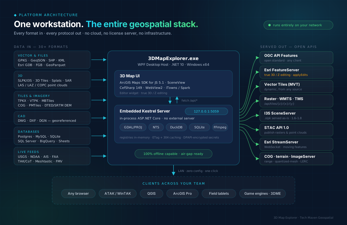
3D Map Explorer turns any Windows workstation into a complete, offline geospatial hub — 3D visualization, true 3D/Z editing, TAK & radar exploitation, imagery intelligence, local AI, RF sensing, offline routing, and one-click LAN-wide data serving. No cloud. No ArcGIS server license. No infrastructure.
.NET 10 · in-process Kestrel
ArcGIS Maps SDK JS 5.1
30+ formats · 12+ protocols
100% offline · air-gap ready
◆ Twenty-eight capabilities · one platform
3D / Z GPKG Editor
Desktop-as-a-Server
3D Visualization (I3S · splats · 3D Tiles)
Analysis + tactical toolkit
Real-Time Feeds
Data Mastery (read · convert · serve)
STAC search & server
Multi-DB Connectors
Full Motion Video (MISB KLV)
CAD Import (DWG/DXF/DGN)
Feeds → Esri StreamServer
Game-Engine Server (Cesium · Unreal · Unity · Godot)
TAK & Tactical Ops
Radar (ASTERIX · CPA · squawk)
SAR Exploitation
Imagery Intelligence
Local AI / ML
RF Sensing (ADS-B · AIS · APRS)
Offline Routing & Nav
GIS Servers & Hub/Living Atlas
GeoPackage Studio
SharePoint Connector
EO Imagery Ordering
3D Reconstruction (LoD2.2)
Plugin Platform
GADM Boundaries
Trajectory Replay
◆ Built for
Defense & IntelEmergency Response
Urban PlanningUtilities & Telecom
Natural ResourcesEngineering / BIM
GovernmentResearch
◆ Why teams choose it
- The desktop is the server. One click shares data LAN-wide over OGC, Esri REST, I3S, STAC — zero config, zero infrastructure.
- Unified, not stovepiped. Radar tracks, TAK blue-force, SAR & imagery exploitation, and RF sensing on one map — no tool-juggling.
- AI without egress. Local LLM chat + NL→SQL, SAM2, and YOLO-E run on your hardware — no cloud AI.
- Data sovereignty by default. Fully air-gap capable; nothing ever leaves the network you control.
- Every format you already have. 30+ file formats plus six databases — even SharePoint lists — served as open standards.
See it in your environment.Pilot programs for qualified teams — live demo, LAN server in minutes, ROI modeled on your data.
⬇ Free Trial: techmavengeo.cloud/software
sales@3dmapexplorer.com