 3D Map Explorer
Your desktop is now a geospatial server.
3D visualization, true 3D / Z editing, multi-format data mastery - and now a full GEOINT workstation: TAK, radar & SAR exploitation, imagery intelligence, local AI, RF sensing, offline routing, commercial imagery tasking, and a plugin SDK. Fully offline.
Tech Maven Geospatial · v1.5.0
GIS data shouldn't need a server farm to share.
- Infrastructure tax - enterprise GIS stacks demand hardware, licenses, and dedicated staff.
- Data sovereignty - cloud sync is a non-starter for classified or regulated data.
- Disconnected ops - field and tactical teams go dark the moment the network drops.
- Format silos - teams are trapped choosing tools by which file they were handed.
One desktop. Every capability.
An embedded local server turns any Windows workstation into a complete, air-gapped geospatial hub - hosting, editing, analyzing, and sharing data across the LAN.
No server
The desktop is the server.
No cloud
Data stays on your network.
No license
No ArcGIS server required.
Everything a geospatial team needs.
3D / Z GPKG EditorNew
True 3D editing over GeoPackage.
Desktop-as-a-Server
One-click LAN sharing.
3D Visualization
I3S, splats, point clouds, COG.
Analysis
Shadow, viewshed, routing, stats.
Real-Time Feeds
Quakes, AIS, TAK, Meshtastic, IoT.
Data Mastery
30+ formats, read & converted.
Five capabilities that landed first.
STAC
Search public catalogs & publish your own.
Connectors
6 databases → MVT / OGC / FeatureServer.
Full Motion Video
STANAG/MISB KLV + DJI→MISB.
CAD Import
DWG / DXF / DGN onto the map.
Feeds & StreamServer
OGC feeds → Esri StreamLayer.
All offline
Served from the in-process host on :5059.
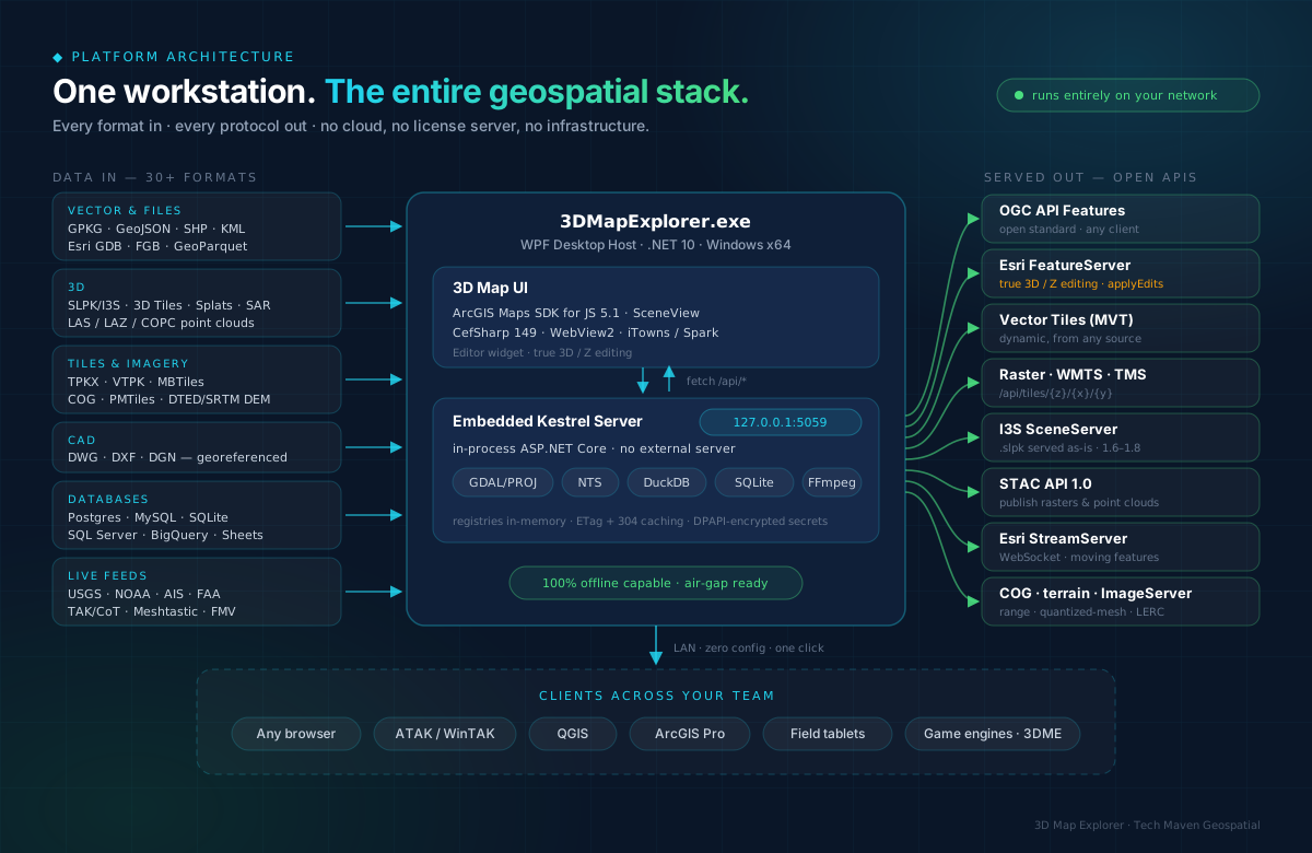
Every format in. Every protocol out.
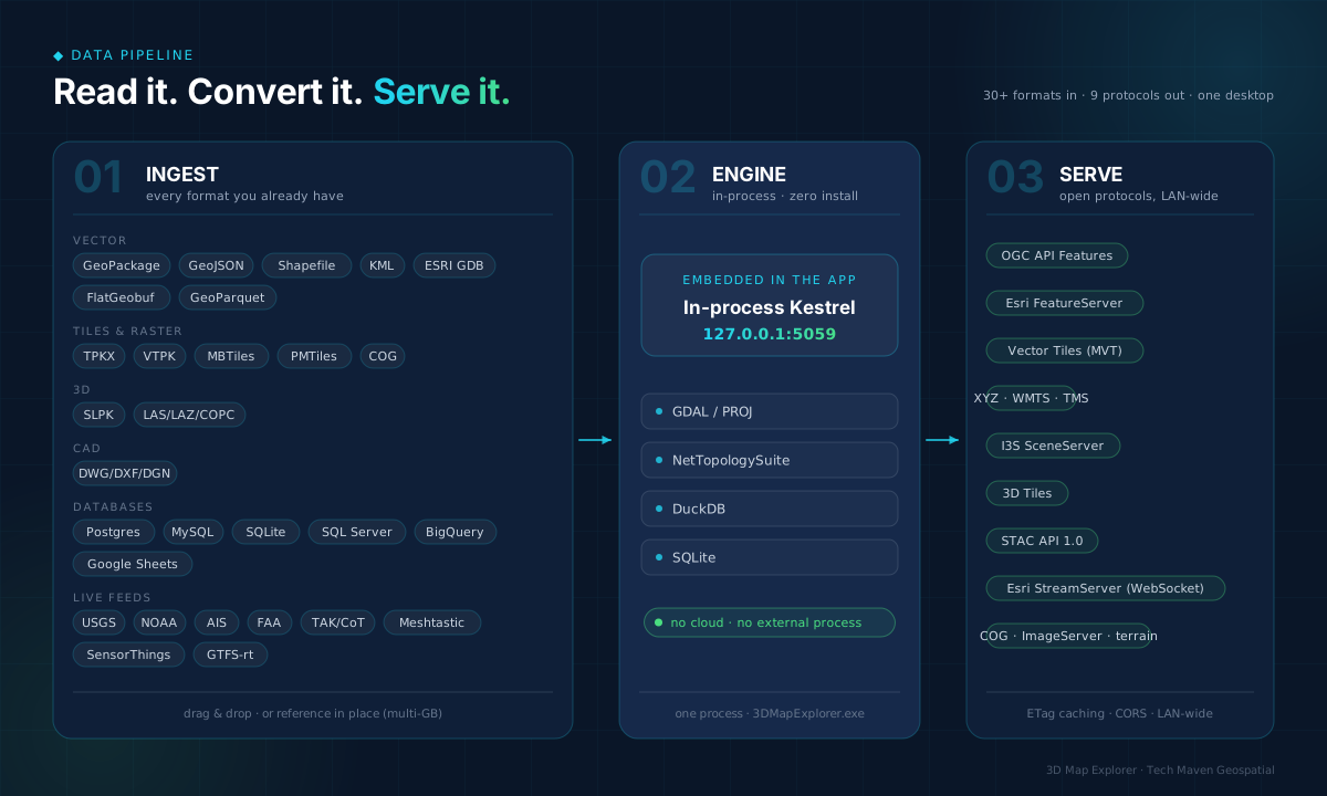
Read it. Convert it. Serve it.
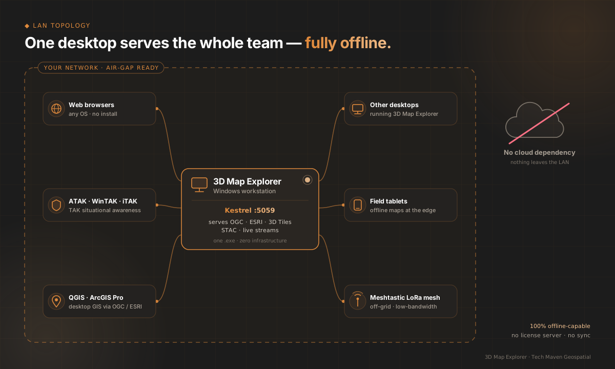
One desktop serves the whole team.
Then it became a GEOINT workstation.
The newest releases add tactical comms, radar and SAR exploitation, imagery intelligence, local AI, RF sensing, offline routing, GIS-server emulation, SharePoint, commercial imagery tasking, 3D reconstruction, and a plugin SDK - sixteen new capabilities on the same desktop.
The COP that speaks CoT.
- TAK Server via STOMP mTLS-wss - or UDP multicast, fully air-gapped.
- Blue-force overlay, GeoChat, missions, alerts, geofencing.
- Mission Board kanban + collaborative canvas + AAR timeline replay.
- TAK Server admin dashboard (Marti REST proxy) + data packages.
- MIL-STD-2525 / APP-6 symbology · CAS & MEDEVAC 9-Lines · CFF · Bullseye.
mission-pkg.zip
├─ manifest.xml
└─ contents/
   └─ cot.xml        // CoT events

● multicast · air-gapped
● geofence ALERT: BFT-2 exited AO
Radar tracks, CPA, squawk alerts - on the map.
- ASTERIX CAT-048 ingestion over UDP multicast.
- Live Track Table - callsign, squawk, flight level, speed, heading, ICAO24.
- CPA calculator - closest point of approach between any two tracks.
- Velocity vectors (3-min lookahead) · trails (last 30 positions).
- Squawk alerting - 7500 / 7600 / 7700 auto-detected.
UAL231  3452  FL340  447kt  094°
DAL88   7700  FL180  322kt  201°
          └─ EMERGENCY · alerting

CPA(UAL231, DAL88)
 → 4.2 nm in 06:12 brg 142°
The RF spectrum, fused onto one map.
ADS-B + RemoteID
Aircraft & drones via readsb / dump978.
AIS
Vessels via rtl_ais + NMEA decoding.
APRS
Stations, WX, objects - RF + APRS-IS.
Audio scanners
Marine VHF · NOAA+SAME · CB · GMRS · MURS.
IoT (rtl_433)
Weather stations, TPMS, ERT, sensors.
One DuckDB hub
Every source queryable + servable.
See at night. See through clouds.
- SAR amplitude viewing - Sentinel-1, speckle filtering, dB rendering.
- ImageServer-grade IMINT: spectral indices (NDVI, NDWI, NBR…), rendering templates, sensor profiles.
- YOLO-E detection: COG window → detect → georeferenced FeatureSet.
- GEOINT annotation & PDF reporting · RPC mensuration with CE/LE.
GET …/ImageServer/exportImage
    ?renderingRule=SarAmplitudeDb

→ analysis-ready backscatter
→ NDVI · NDWI · NBR on demand
AI that never phones home.
- Gemma 3 / Phi-4 local LLM - geospatial chatbot + NL→SQL over your layers.
- SAM2 segmentation on imagery.
- YOLO-E detection on stills and FMV - detections can broadcast as CoT.
- llama.cpp sidecar on your hardware - no cloud AI, no data egress.
// "vessels under 10kt near the port"
SELECT * FROM ais_tracks
WHERE sog < 10
  AND ST_DWithin(geom, port, 2000)
→ layer on the map
Turn-by-turn that never phones home.
- In-process A* over your own DuckDB road graph - no OSRM, no Docker, no cloud.
- Multi-waypoint solves with per-leg turn-by-turn.
- Vehicle / foot / cycle modes · GPX 1.1 + KML 2.2 export.
- City/region scale (~100k nodes) solves in <1s.
- Optional Esri World Routing toggle when online (credits apply).
{
  "origin": {"lat":34.05,"lon":-118.24},
  "dest":   {"lat":34.09,"lon":-118.36},
  "options": {"travelMode":"vehicle"}
}
→ route + legs + instructions
Speaks every server's language. Then becomes one.
Consume
ArcGIS Portal / Server / AGO, GeoServer, QGIS Server, MapServer.
Emulate
FeatureServer · ImageServer · StreamServer · SceneServer · tiles.
Hub & Living AtlasNew
Browse, search, download, load-to-map.
GeoPackage Studio
Design, import, edit, export - plus Z editing.
GADM boundaries
3-level admin breakdown, offline.
Connect-to-GIS
Discoverable catalog for QGIS / ArcGIS Pro.
Your SharePoint lists are map layers now.
- Any list becomes a FeatureLayer, vector tiles, or OGC Features.
- Entra ID delegated sign-in (PKCE) - every edit attributed to the operator.
- Five geometry shapes auto-detected - lat/lon, Geolocation, WKT, GeoJSON, address.
- Edit in the attribute table - writes flow back via Microsoft Graph, delta sync refresh.
// Incident Reports list → layer
GET /api/spatial/{id}/FeatureServer
PATCH → Graph listItem ✓ written back
// delta sync: only changed rows
Task the bird from the map.
- Planet · Sentinel Hub · Skywatch · SkyFi - your own accounts.
- Draw an AOI, filter by date / cloud cover, search four catalogs in one dialect.
- Archive and tasking orders with live status polling.
- Delivered scenes land as map layers; Sentinel Hub can live-stream tiles with no purchase.
- The app never handles billing - every call runs under your credential.
{
  "aoi": "drawn bbox",
  "cloudCover": {"lt": 15},
  "source": "PSScene, sentinel-2-l2a"
}
→ unified EoScene[] · 🛒 order
Rebuild the city. Extend the platform.
roofer LoD2.2
Point cloud + footprints → CityJSON building models (the 3DBAG engine).
FUSION/LDV
30-command forestry LiDAR toolkit.
Splat training
Postshot / COLMAP / OpenSplat pipeline.
Plugin SDKNew
One folder: manifest + .NET + TS tiers.
Extension points
REST routes, sidebar tools, workers, layer types.
Drop-in install
No rebuild of the app - discovered at startup.
Unified where everything else is stovepiped.
| Capability | Commercial GIS | Defense systems | 3D Map Explorer |
|---|---|---|---|
| Air-gapped operation | limited | yes | yes, by default |
| Radar + imagery + TAK unified | no | stovepiped | one map |
| 90+ searchable tools | no | no | yes |
| Open data formats | partial | limited | GPKG · COG · DuckDB · OGC |
* Comparative rows are positioning statements, not benchmark results.
Built for the operations floor.
- Tactical Operations Center - radar + blue-force + imagery in one common operating picture.
- Maritime domain awareness - AIS + radar + SAR imagery on one map.
- Disaster response - emergency symbols + live feeds + tasked commercial imagery.
- Border security - sensor fusion + geofencing + CPA deconfliction.
- Training & simulation - CDB 2.0 synthetic environments + game-engine terrain serving.
Search the world. Publish your own.
- Browse Element 84 & Planetary Computer from one search box.
- Auto-detects CQL2 vs the
queryextension; SAS signing handled. - Publish a folder of rasters + clouds as a STAC API 1.0.0 at
/stac.
{
  "collections": ["sentinel-2-l2a"],
  "datetime": "2026-05/2026-06",
  "query": {"eo:cloud_cover":{"lt":10}}
}
→ ImageryTileLayer, signed
Map the data you already have.
Postgres / PostGIS
postgres_scanner
MySQL
mysql_scanner
SQLite · MSSQL
bundled + ODBC
BigQuery
ADC attach
Google Sheets
lat/long virtualized
3 facades
MVT · OGC · FeatureServer
Drone video, geo-locked.
- Parses MISB ST 0601 KLV; live RTSP/UDP/SRT streams.
- Sensor footprint tracked on the map frame-by-frame.
- DJI → STANAG conversion from SRT / flight logs / EXIF.
- Optional YOLO-E object detection sidecar.
// DJI clip + telemetry → STANAG .ts
POST /api/fmv/dji-convert
  file   = DJI_0012.MP4
  srt    = DJI_0012.SRT

→ MISB ST 0601 .ts
→ footprint on map ✓
Engineering plans meet the real world.
- Reads DWG / DXF / DGN via managed OGR +
ogr2ogrfallback. - Georeference with control points (affine / polynomial-2, RMSE preview) or source EPSG.
- Outputs GeoJSON, MBTiles-vector, or GeoPackage - reprojected to EPSG:4326.
- Served as tiles, OGC Features, and FeatureServer under
/api/cad/{id}.
Live feeds in. ArcGIS StreamLayer out.
- Subscribe to SensorThings · SOS · GTFS-rt · Moving Features into DuckDB.
- Raw WebSocket StreamServer speaks the Esri JSON protocol - no SignalR.
- Per-subscriber
wherefilters + DuckDB-backed history. - Meshtastic, TAK, GNSS tracks → native ArcGIS StreamLayer.
GET /api/stream/{id}/StreamServer
 → streamUrls[0].url

ws  /api/stream/{id}/subscribe
POST /api/stream/{id}/ingest
GET  /api/stream/{id}/query
     ?startMs=&endMs=

// paste URL into ArcGIS Pro
Edit geospatial data in true 3DNew
- Full Z + M ordinate round-tripping - ESRI JSON ↔ NTS ↔ GPKG blob.
- ESRI-compatible FeatureServer REST contract.
- Native ArcGIS Editor widget.
- Schema-driven
hasZ/hasM.
{
  "geometry": {
    "x":-74.006,
    "y":40.712,
    "z":1500.5
  }
}
// z preserved exactly ✓
Zero infrastructure. One click.
- One-click activation - share in seconds.
- Auto DHCP - zero manual configuration.
- Universal access - any OGC/ESRI client.
- Real-time monitoring of endpoint health.
GET /api/features      OGC
GET /tiles/{z}/{x}/{y} raster
GET /cog/tiles/…       COG stream
GET /api/featureserver ESRI

● live on 192.168.1.24
Multi-protocol serving.
OGC API Features
Modern RESTful feature API.
ESRI REST
FeatureServer / ImageServer.
3D Tiles
Streaming massive 3D.
Vector Tiles
Fast PBF rendering.
COG
HTTP range streaming.
SpatiaLite / DuckDB
ST_AsMVT analytics.
Render every kind of 3D reality.
I3S from .slpk
IntegratedMesh, 3DObject, Point.
Gaussian Splats
.ply/.splat/.spz via Spark.
LiDAR Point Cloud
LAS/LAZ/COPC → I3S SLPK.
OGC 3D Tiles
iTowns streaming.
Cloud GeoTIFF
Range-streamed imagery.
Scene Controls
Lighting, shadows, atmosphere.
Decide with the terrain.
- Shadow & solar-potential analysis.
- Viewshed, line-of-sight, slope & aspect.
- Routing & multi-stop optimization.
- Hot-spot, clustering, spatial statistics.
- Elevation profiles & 3D measurement.
{
  "observerZ": 100,
  "viewDistance": 1000
}
→ 360° visibility, mapped
The world, live on your map.
USGS
Live earthquakes.
FAA / AIS
Aircraft & vessels.
Meshtastic
Off-grid LoRa mesh.
TAK / CoT
ATAK / WinTAK / iTAK.
APRS
Amateur radio positions.
IoT & Sensors
Custom device streams.
One shared picture for the whole team.
XMPP Chat
Local, open-standard.
VoIP / WebRTC
Voice coordination.
Team Awareness
Live positions & status.
All channels run over the in-process local server - your conversations never leave the network you control.
Air-gapped. By default.
Runs entirely offline. Ideal for classified, regulated, and remote environments. Distributed by nature - any workstation becomes a server, so there's no single point of failure.
A modern, dependency-light stack.
- .NET 10 · WPF desktop host with in-process ASP.NET Core / Kestrel - or the same host headless on Linux.
- CefSharp.Wpf.NETCore 149 + WebView2 for hardware-accelerated rendering.
- ArcGIS Maps SDK for JavaScript 5.1 - primary SceneView.
- NetTopologySuite 2.6.0 · DuckDB · SpatiaLite · GDAL · OGR.
- iTowns · Spark · Three.js - all vendored locally for air-gap use.
- MISB ST 0601 KLV · STAC API 1.0.0 · GTFS protobuf · raw WebSockets for StreamServer.
* Reflects the .csproj / ARCHITECTURE.md build, not the stale README stack.
Built for the field, the desk, and the edge.
Defense & Intel
Secure classified sharing.
Emergency Response
Live damage assessment.
Urban Planning
3D city models.
Utilities
Underground modeling.
Natural Resources
Mining, forestry, geology.
Government
Data sovereignty.
From data to decision in minutes.
- Emergency response - field teams share real-time assessments; command aggregates every stream.
- Urban planning - engineering, zoning, and environmental layers in one shared view.
- Defense & intel - secure sharing within classified networks; multi-source fusion.
- Environmental - research stations stream sensor data; live habitat modeling.
* Scenario impact figures are illustrative planning targets.
The GIS server you don't have to buy.
| 5-year TCO | Traditional | 3D Map Explorer |
|---|---|---|
| Total cost | $565,000 | $32,000 |
| Net avoided | $533,000 | |
* All ROI / TCO figures illustrative - from internal planning docs.
Why not the alternatives?
| Enterprise GIS Server | Cloud GIS | 3D Map Explorer | |
|---|---|---|---|
| Deployment | weeks | hours + cloud setup | seconds |
| Hardware | dedicated | cloud subscription | existing desktop |
| Data control | on-prem | leaves org | LAN-only |
| Offline | limited | no | fully air-gapped |
| Cost | high | recurring | low, fixed |
“Network Data Sharing reduced our emergency response time by 45 minutes, potentially saving lives.”
- Emergency Management Director, Major Metropolitan Area
Choose your deployment.
Starter
5 users · basic training · email support.
Professional
25 users · priority support · full pillars.
Enterprise
Unlimited · dedicated success · air-gapped.
* Draft planning tiers - final pricing to be confirmed.
Plan → Preflight → Fly → Process → Exploit.
A complete uncrewed-aircraft capability set on one desktop - no separate tool per phase.
Preflight
Airspace, TFRs, METAR gate → Go/No-Go.
Payload
Live gimbal + RGB/thermal + zoom (MAVLink).
RTK / PPK
NTRIP→RTCM relay + PPK trajectory.
BVLOS
Fused traffic + comm-link LOS + deconfliction.
Counter-UAS
Radar ingest + threat + Remote ID correlation.
Process & Exploit
Orthomosaic, flight-log replay, oriented imagery.
Before you fly - one verdict. In flight - command the sensor.
- Bundled controlled airspace + TFR overlay + mission-footprint intersection.
- METAR wind gate + checklist → a single Go / No-Go verdict. LAANC-aware (Phase-2: auto-filing).
- Live gimbal attitude, RGB↔thermal switching, zoom - the first outbound MAVLink command path (MAV_CMD 1000/510/531).
- NTRIP → RTCM3 → MAVLink relay for live RTK; PPK trajectory recovery vs. base RINEX (Phase-1 honest degrade, full carrier-phase math on roadmap).
{
  "status": "Caution",
  "reasons": ["LAANC required: Class-B"],
  "weather": { "windKt": 8 }
}
→ one verdict before every flight
Over the horizon, not in the dark.
- Fused traffic - Remote ID + MAVLink own/friendly + ADS-B crewed → one normalized picture.
- Terrain-sampled comm-link LOS - does the radio link clear the ridge? (the BVLOS differentiator).
- Closing-rate deconfliction with Caution/Warning thresholds + SSE proximity alerts.
- Counter-UAS - radar PUSH webhook → conservative threat assessment vs. protected assets.
- C-UAS ↔ Remote ID correlation de-escalates friendly drones. (Phase-2: RF detection.)
{ "type": "FixedWing", "speedKt": 55 }
→ assessed + correlated
{
  "threat": "Hostile",
  "correlatedRemoteId": null
}
// broadcasting Remote ID → de-escalated
Photos in - map, model, and catalog out.
Flight-log replay
.tlog / .bin / .csv → time-animated trajectory. Feeds PPK + fleet.
Fleet manager
Registry, flight-hour rollup, maintenance-due, battery cycles.
Orthomosaic / SfM
Local ODM CLI sidecar (air-gapped) + WebODM cloud import.
Oriented Imagery
Drone photos by capture pose - derived from FMV or EXIF → ArcGIS Feature Service.
+ Full Motion Video
STANAG/MISB KLV playback with live sensor footprint.
One platform
The whole loop - no tool per phase. Air-gapped by default.
The roadmap.
- Now - 3D/Z GPKG editing, local FeatureServer, full format mastery.
- Next - advanced 3D analysis (KNN, volume, slice), enhanced auth layers.
- Enterprise - centralized management console, Active Directory integration.
- Innovation - AI-assisted data discovery, predictive analytics, AR/VR collaboration.
* Roadmap items are forward-looking and subject to change.
Step inside the scene. Tag the world from a panorama.
360° viewer
Equirect · cubemap · 360-video
Click-to-place tags
Raycast → geodesic ground point
AI auto-tag
YOLO-E perspective sweep
Telemetry
GPX · DJI · ffprobe · SRT
Live map sync
Camera + FOV frustum + tags
Six-face cubemaps
Auto-sorted face order
Enterprise sources, web sources, event-driven - all onto the map.
ServiceNow
Incidents + CMDB, read + write-back + poller
DLT data loading
60+ verified sources + REST + SQLAlchemy
Web crawler
Pages · sitemap · discover - pure SQL
Events tap
DuckDB trigger → webhook / SSE / file
Project model
Portable .tmgproj + VIEW-default hub
Folder watcher
Drop a file → on the map in ~2 s
The whole engine. None of the desktop.
- Every API, geoprocessing routine, and serving endpoint - as a headless Linux service. Not a fork: one source tree, two build targets.
- DEB · RPM · Helm · Docker - native packages for Ubuntu/Debian and the RHEL 9 family, a Kubernetes chart, and an air-gapped image.
- No ArcGIS Maps SDK viewer - bring your own renderer, or serve a compiled web map straight from a folder.
- Pairs with MapLibre GL Native on QNX or hardened Linux - vehicle, airborne, and industrial deployments.
- Hardened systemd unit, unprivileged user, AES secret envelope, data durable across upgrades.
# enterprise Linux
apt install ./3dmapexplorer-server_*.deb
dnf install ./3dmapexplorer-server-*.rpm

# cluster
helm install tmg ./3dmapexplorer-server

# container
docker run -p 5059:5059 3dmapexplorer-server

● same REST + SSE surface on :5059
● your web map at /apps/{slug}/
Ready to see it in action?
Run the installer. In seconds your workstation is hosting, editing, and sharing 3D geospatial data - no cloud, no license server, no waiting.
Tech Maven Geospatial, LLC · 1856 North Nob Hill Road, Suite #216, Plantation, FL USA 33322-6548
3D Map Explorer · Empowering Geospatial Intelligence · v1.5.0